

Green Infrastructure Projects Will Help Reduce Risks of Urban Flooding
New book by UC Davis and UCSB scientists highlights investments California has made to help humans, wildlife thrive
UC Davis and UCSB scientists recently published a book, “Floodplains: Processes and Management for Ecosystem Services,” which recommends green infrastructure fixes to help reduce flooding risks in urban areas.
“Floodplains are low-lying areas along [rivers] that will fill up during high flows with water,” said Amber Manfree, a post-doctoral researcher at the UC Davis Center for Watershed Sciences and one of the authors of the book. “They could be forested, they could be open grassland, or any kind of land cover. The thing about them that is really great is when the water comes up and fills the floodplain, it becomes habitat for aquatic organisms. Particularly, if it’s exposed to at least some sunlight, it works as a big solar panel, and will produce a lot of food, which will very much increase the amount of productivity in the ecosystems.”
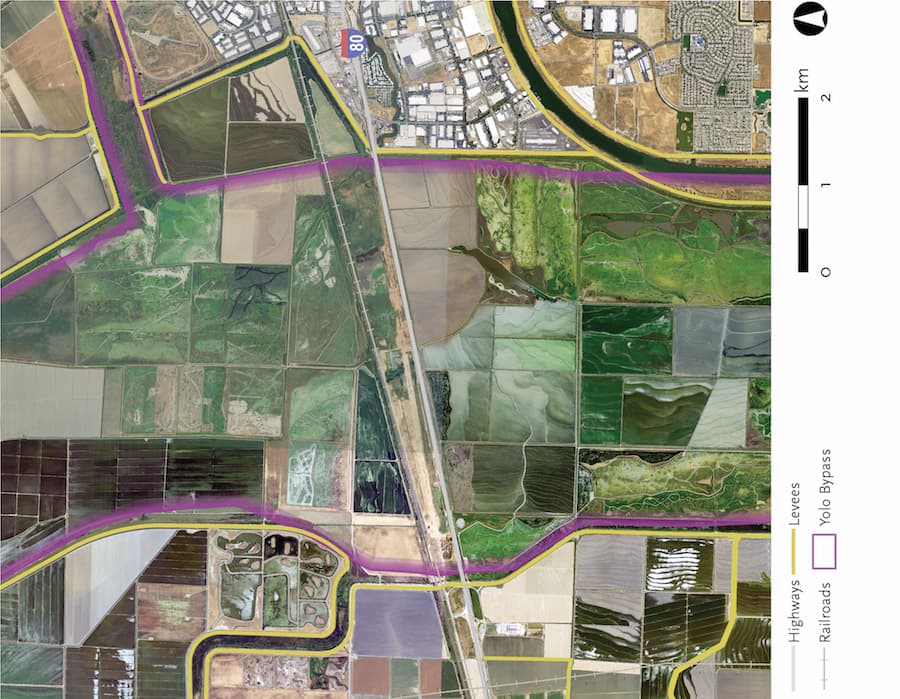
Levees and dams, “grey infrastructure,” are rigid structures built to reduce the risk of flooding. Unfortunately, they can also damage wildlife processes and disrupt complex ecosystems. Green infrastructure includes seasonal projects which can be flexible to changing weather conditions, such as the Yolo Bypass between Davis and Sacramento. The bypass provides habitat for birds and fish in the wet winters. Much of the land in the bypass is used for agriculture during the summer, taking advantage of the sediment deposited by the flooding.
“The Yolo Bypass is one of the best examples in the world on how to use the floodplain right,” said Peter Moyle, a professor emeritus at the UC Davis Center for Watershed Sciences and one of the authors of the book. “It’s got rice and other crops, and of course, pastures, too. It’s got a wildlife area, major place for overwintering waterfowl, swans and everything else. Then you have the flooding in the winter that turns out to be really good for fish. What’s so interesting is that the discovery that salmon benefited from floodplains, which is something we basically documented in my lab for the first time about twenty years ago, was new stuff.”
The Yolo Bypass, along with the Sutter Bypass, the Butte Sinks, and the Fremont Weir, help drain the Sacramento River as it winds through the Central Valley. The flowing water and rich sediment contribute to the famously productive farmland of California.
“The Sacramento system is pretty well-studied,” Manfree said. “There’s been a lot of work in understanding the system, and using it as a model to understand floodplain systems in general.”
When water reaches a level that could threaten the city, it spills over and diverts away into the Yolo Bypass area, creating excellent habitats for fish and birds. Flooding is a natural process in many rivers, and help contribute to ecosystems, but can devastate urban areas which are not prepared.
“Even with the bypasses, Sacramento remains, statistically, one of the most at-risk cities [for flooding],” said Jeff Opperman, the lead global freshwater scientist at the World Wildlife Fund and the lead author of the book, which stemmed from his post-doctoral studies.
The City of Sacramento is situated at the junction of the American and Sacramento Rivers. Historically, the city battled severe floods for decades before the Yolo Bypass was created nearly a hundred years ago.
“One of the things we feature in the book is how California has taken some very smart steps to manage floods,” Opperman said.
Other states have not embraced green infrastructure projects with the same enthusiasm. When Hurricane Harvey parked over Houston, Texas for an entire weekend, the few flood protection defenses of the metropolitan area were overwhelmed.
“Houston is like Sacramento,” Moyle said. “There are places they could build bypasses. You could create a floodplain area, you could farm it most of the time. But they’ve chosen to develop those places instead, and they get flooded.”
Much of Texas is mostly flat land at sea level, and Houston is near the Gulf of Mexico with a few river systems flowing through the urban area. Houston experiences severe floods regularly due to rampant development without proper drainage systems or green infrastructure projects such as the bypasses in California.
“The U.S. has large urban infrastructure at risk of flooding all around the country,” said Nicholas Pinter, a professor in the Department of Earth and Planetary Sciences. Pinter has researched the Houston floods and has shared some of his work at the California Water Blog.
Certain areas in the United States have not taken enough action to reduce the risks of flooding. Some homes have been flooded a dozen times or more, but remain in the same location or have not augmented their homes to better deal with floods.
“The worst repetitive loss property nationwide by losses is forty,” said Pinter. “Forty times, forty separate floods, forty payouts.”
Instead of repairing homes over and over in the middle of predictable floodplain areas, taxpayer monies could be invested in wildlife areas where threatening floodwaters could flow safely away from urban areas.
“Societies are going to go broke if they just keep fixing climate change problems as if it’s never going to happen again,” Manfree said. “Because the thing is, it’s going to keep happening, and you need to adjust to that.”
California has taken measures to invest in flood protections, such as planning to expand the Yolo Bypass, but more work needs to be done to protect the state from stronger storms and bigger floods coming in the future. Other states in the nation can invest in their own types of green infrastructure, following “The Accidental Model” of the Yolo Bypass, as Opperman calls it. The bypass was intended to save human investments in Sacramento, but has also succeeded as a wildlife area where birds and fish can overwinter and develop in peace.
“By integrating these natural features into flood management systems, we have a much better chance at finding this balance,” Opperman said.
Written by: George Ugartemendia — science@theaggie.org