Satellite technology allows anyone with a computer to aid archeologists in unearthing new discoveries about ancient civilizations
Satellite technology has given rise to what is known as space archeology — using high-resolution imagery to detect unknown objects hidden beneath the Earth’s surface. Sarah Parcak is a pioneer of this field, and she wants us all to become space archeologists.
“I have a passion for finding things,” Parcak said in her 2016 TED Talk. “Seeing with the naked eye alone wasn’t enough.”
Starting with a search for sand dollars on the beaches of Maine as a child, now Parcak unearths ancient cities beneath the sands of Egypt.
Parcak began using this digital map in 2011 and now shares it with the public. Using high-resolution satellite imagery, Parcak’s online platform GlobalXplorer uses infrared and image processing to detect chemical changes in the landscape caused by hidden objects beneath the surface. It’s like Google Earth for archaeologists.
Randy Haas is an archaeologist at UC Davis utilizing this satellite technology.
“I am indeed an advocate of the method,” Haas said. “Sarah Parcak’s excellent work has certainly inspired me to explore crowd-based satellite image surveying for archaeological discovery.”
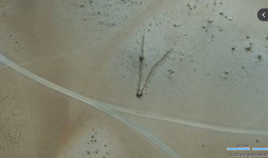
Probing the Andes Mountains from 400 miles above the Earth, Haas noticed V-shaped structural patterns in the high-resolution satellite imagery. Further examination led to the inference that the ancient indigenous people may have used this geometry as a barrier to herd vicuña, a wild ancestor of the alpaca, for wool. Haas now turns to his students to help him further his research.
Teaching for his first quarter at UC Davis, Haas is allowing students in his ANT 3: Introduction to Archaeology class to become space archeologists themselves.
“Students will be surfing satellite imagery in the Andes Mountains of Peru to help me find archaeological sites that I suspect are related to ancient wild animal roundups,” Haas said.
On the first day the assignment was released, 34 new sites were found, and five have been confirmed thus far. Now, Haas can return to Peru using a newfound map with the potential to unearth untold history, giving new insight into human behavior.
This summer, UC Davis’ Institute for Social Sciences will fund an archeological field effort using this satellite technology for ground-based operations.
The use of satellite technology is revolutionizing the world of archeology. In the Egyptian delta alone, archaeologists have excavated less than 1/100th of 1 percent of the total volume of sites in Egypt. Using NASA’s topography data and an army of newly-trained space archeologists, countless numbers of archaeological sites will be discovered. This will lead to clues that have been hidden for thousands of years.
“Satellite imagery will play an increasingly important role in archaeological discovery and preservation, especially as new detection algorithms and satellite systems are developed,” Haas said.
Parcak’s goal is to launch space archeology worldwide, giving anyone with a smartphone or computer the ability to unravel the mysteries of the past.
Naturally, sharing this technology with the world has some consequences. Thieves loot archeological sites and sell parts of history for personal profit. From miles above, looting sites look like small craters from Mars. In the wrong hands, the GPS data could increase looting universally.
“Every archaeologists has had to cope with looting,” Haas said, who has witnessed looting firsthand at one of his own digs in Peru. “It is a harsh reality.”
Bryna Hull, a second-year Ph.D. student specializing in California prehistory, is a TA for Haas’ anthropology class and explains why looting is so harmful.
“Many people don’t realize that it destroys the scientific value of the items they take when they remove them from their context and fail to document anything,” Hull said.
Contrary to popular belief, looting has been increasing worldwide. And at its current rate, according to Parcak, all of the archeological sites in Egypt will have been looted by 2040.
That is why Parcak masks the information, and keeps the GPS coordinates secret — just like a doctor protecting a patient’s medical records.
Today, NASA has a specific program to train future space archeologists. The next major discovery in archeology could be mapped from anyone with access to the internet.
Written by: David Madey — science@theaggie.org


