

New research uncovers evidence of shared earthquakes between San Andreas, San Jacinto faults
The study, done by geologists at UC Davis and San Diego State University, could improve future earthquake predictions
By SONORA SLATER — science@theaggie.org
The year is 1812, and a 7.5 magnitude earthquake has just devastated Spanish missions across southern California. The San Andreas fault is to blame — but, based on new research from geologists at UC Davis and San Diego State University, it might not have been the only one.
According to the study, the San Andreas and San Jacinto faults have ruptured simultaneously at least three times in the past 2,000 years, most recently in 1812. This joint rupture could be the cause of stronger earth shaking from the combined events, which changes our understanding of the past as well as playing into modeling predictions for future earthquakes.
Tom Rockwell, a professor of geology at San Diego State University and the paleoseismic expert on the study, described how the project came about. As a paleoseismologist, Rockwell analyzes sediment along faults for evidence of historical earthquakes.
“I was involved in paleoseismic studies in the northern San Jacinto Fault, and we were coming up with earthquake ages that were very similar to those on the San Andreas Fault,” Rockwell said. “So there was a question of whether perhaps the San Jacinto and San Andreas had ruptured together.”
He went on to explain that Mike Oskin, a professor in the Earth and Planetary Sciences Department at UC Davis, reached out to him about a joint rupture research project. The project involved the smaller Lytle Creek Ridge Fault, located between the San Andreas and San Jacinto. Rockwell agreed to collaborate on the research, and the two wrote a proposal to receive funding.
Rockwell then elaborated that while there has been speculation of joint rupturing at several different faults across the state, Lytle Creek Ridge lent itself particularly well to uncovering the “paleoseismic record of past slip events.”
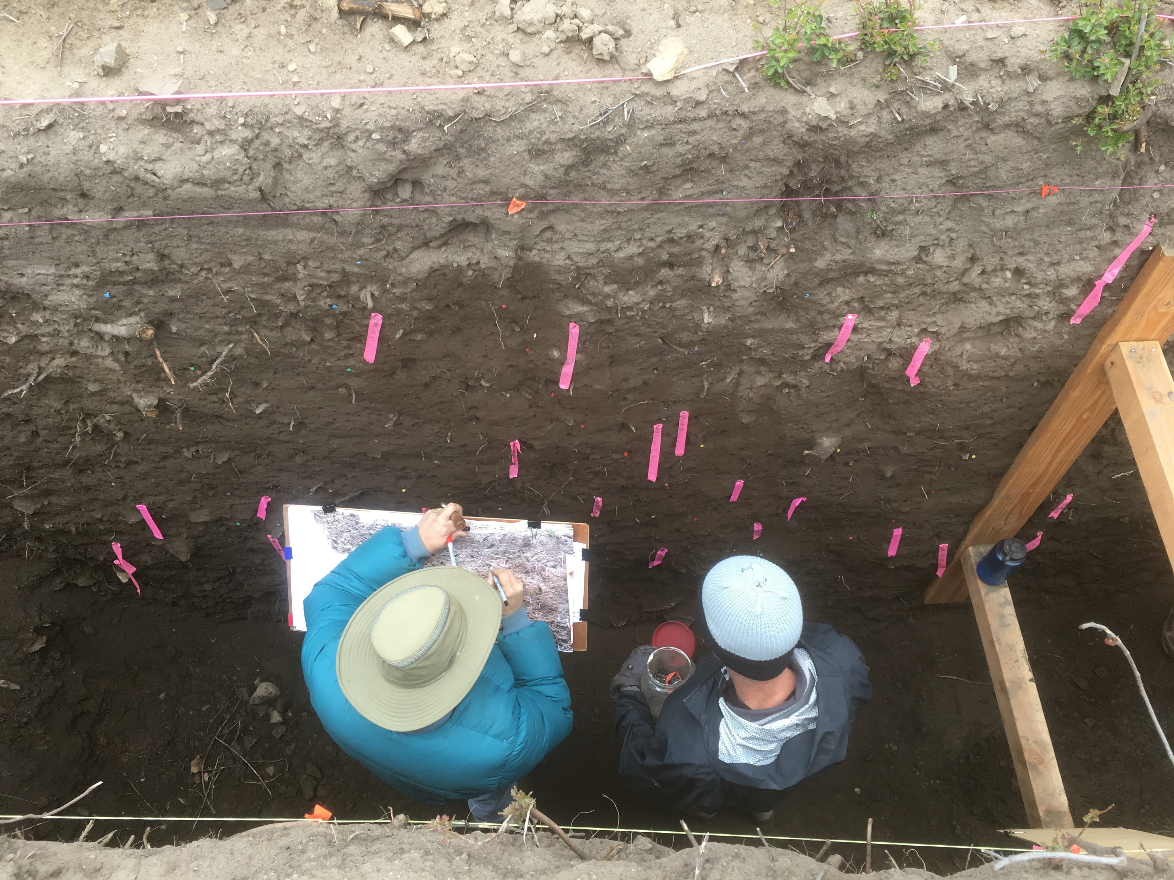
According to Rockwell, this paleoseismic record is contained in layers of sediment. In order to reveal them, paleoseismologists use a method called trenching.
“We excavate trenches across the fault, and we look for fault strands that break up to a certain level and then are buried,” Rockwell said.
Oskin elaborated on what this looks like, explaining that when an earthquake occurs, it “cuts up to the surface and offsets the surface.” This means that when trenching is done many years later, paleoseismologists can observe the uneven layers of sediment and know that an earthquake had occurred.
Rockwell explained that once they found evidence of an earthquake in the trench, they could infer that the top layer of the offset sediment “was the ground surface at the time of that particular earthquake.” Therefore, if the team could date the sediment, they would know when the earthquake had happened.
One way to date sediment is through radiocarbon dating — after finding evidence of multiple earthquakes in the trenches of the fault, the researchers collected samples of charcoal from the sediment to use in determining the age of the sediment layer.
“Basically, charcoal has carbon that decays after the sample burns,” Alba Rodríguez Padilla, a fourth-year Ph.D. candidate at UC Davis and first author on the paper, said. “So, things start decaying the moment something burns, and then you can look at the amount of the decayed product in the charcoal and figure out when that originally burned. And then that can give you a sense of when the plant grew.”
However, according to Rockwell, there are challenges with using radiocarbon dating to obtain specific dates within the past 350 years.
“We put so much dead carbon into the atmosphere from the industrial revolution forward that the calibration curve is almost flat,” Rockwell said. “Whenever we try to calibrate young radiocarbon dates, we get multiple intercepts, multiple potential time windows. What we want to know is more specifically, was this related to 1812? […] So we needed to use pollen.”
Rodríguez Padilla explained how Irina Delusina, a palynologist — or pollen scientist — at UC Davis was able to use the pollen in the sediment samples collected in the trenches to date the earthquakes.
“We know when certain pollen species were introduced into California by Spanish colonizers,” Rodríguez Padilla said. “So, if you look at your layer of dirt and you find the sample of that pollen species, you can figure out that that layer had to be deposited following the introduction of that sample to California.”
This method of identifying the pollen of plants like tumbleweed and spanish broom combined with the time intervals that the radiocarbon dating provided, was able to definitively confirm that the sediment samples were from the 1812 earthquake.
According to Rodríguez Padilla, after the dates and chronology of the earthquake were put together, she began using the field data in collaboration with numerical modeling to learn more about what the 1812 earthquake might have looked like.
“Someone had previously speculated that the San Jacinto fault was also involved in the 1812 earthquake, and he had done this through modeling,” Rodríguez Padilla said. “So we took his models, and we put our little fault in the middle, and we tested different possibilities based on his original models that would allow for our small fault to have the amount of motion we found inside our trench. […] Based on that, we were able to learn something about what earthquakes that involve both faults look like.”
Oskin explained how this modeling, especially if the same method is used to look at other potential joint rupture faults in the future, could contribute to a better understanding of what determines earthquake intensity.
“If we can identify patterns, we can start to say more definitively what determines size and intensity,” Oskin said. “By understanding how faults can link together, and how likely that is, we’d have a much better idea of the size range of what’s possible.”
According to Oskin, “the earthquake problem has a lot of broad societal impacts.” Rodríguez Padilla agreed, and talked about how the modeling done for this research could have a real impact on the lives of Californians.
“Something I really like about this project is that it has direct applicability,” Rodríguez Padilla said. “[This research is] built into models that look at the frequency of when earthquakes will happen in California over thousands of years, and it is those models that get used to set earthquake insurance rates in California. So we are producing a data point that will directly inform what someone’s house gets insured at.”
Rockwell added some final thoughts about what he believes the significance of the research to be.
“This helped clarify what could happen, because it did happen,” Rockwell said. “I think that’s the important thing — you can speculate about joint rupture, but if you don’t have any direct evidence for it, it’s just speculation. So this study helped illuminate that aspect that it looks like joint ruptures are not only possible but they happen, and they’ve happened recently.”
Written by: Sonora Slater — science@theaggie.org